
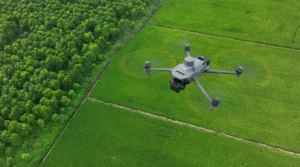
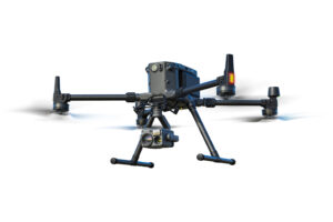
What is Mavic 3M
The Mavic 3M is a compact, foldable, enterprise‑grade drone from DJI, tailored for agriculture, surveying, environmental monitoring, and other tasks needing multispectral + RGB imaging with precision.
It combines a 20 MP RGB camera with a 4‑band multispectral camera (Green, Red, Red Edge, Near Infrared) — enabling data capture beyond visible light, such as vegetation health, crop analysis, land/soil health, etc.
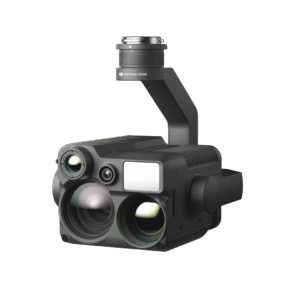
Cameras & Imaging System
RGB Camera: 4/3″ CMOS, 20 MP, mechanical shutter — for high‑quality visual images/photos.
Multispectral Camera: Four 5 MP sensors covering G/R/RE/NIR bands. Useful for crop health monitoring, vegetation analysis, environmental surveys, forestry, water/soil monitoring etc.
Because of this dual imaging capability — visible + multispectral — Mavic 3M is especially suitable where data beyond human vision is needed (e.g. NDVI maps, detecting plant stress, planning irrigation/fertilization, land‑use analysis).
Flight Performance & Features
Flight Time: up to 43 minutes (no wind) — gives good coverage per mission.
Maximum Flight Distance: up to 32 km (in ideal conditions).
Portability: Foldable design — compact and transport‑friendly — useful for fieldwork or remote areas.
RTK Positioning (optional / integrated): Enables centimeter-level positioning accuracy, which is important for precision agriculture, mapping, surveying — ensures spatial accuracy of images/data even without ground-control points.
Omnidirectional obstacle sensing + safe/stable flight controls, enabling safer flights even in complex terrain or near obstacles.
Efficient Coverage: On a good flight, can cover large areas quickly — making it suitable for surveying farms, forests, water bodies, environmental zones, etc.


Reviews
There are no reviews yet.